What's under your lot matters as much as what's on it. A geotechnical engineer investigates the ground conditions that will determine your foundation design. They also assess whether your slope is safe to build on and what seismic forces your structure must handle. On Vancouver Island, where geology ranges from solid rock to marine clay within a few kilometres, a geotechnical investigation is the basis for every structural decision that follows. They are a key member of the development team.
When Is a Geotechnical Investigation Required in BC?
Municipalities across Vancouver Island require geotechnical reports in several situations. While specific triggers vary by jurisdiction, you'll generally need a geotech report when your project involves:
- Slopes greater than 15%: Most municipalities designate steep slopes as Development Permit Areas (DPAs), requiring a geotechnical assessment before any building permit is issued
- Fill areas: If your property has been previously filled, common in areas near harbours, former agricultural land, or low-lying terrain, the fill material needs to be assessed for bearing capacity and settlement potential
- Known hazard zones: Areas identified in municipal Official Community Plans as having geohazard risk (landslide, erosion, flooding, or liquefaction potential) trigger mandatory assessments
- Retaining walls over 1.2 metres: Any retaining wall above this height threshold typically requires engineered design based on a geotechnical assessment
- Multi-unit or Part 3 buildings: Larger developments virtually always require geotechnical investigation as part of the building permit process
- Septic system installation: Properties outside municipal sewer service require percolation testing and soil assessment for septic design
Vancouver Island Geology: A Diverse and Challenging Landscape
Vancouver Island's geology is remarkably varied. Understanding what's likely beneath your property helps set expectations for the scope and cost of investigation.
Bedrock (Victoria, Oak Bay, Parts of Saanich)
Much of Greater Victoria sits on shallow bedrock — metamorphic and igneous rock scraped clean by glaciers. Properties in Rockland, Gonzales, and parts of Oak Bay may hit solid rock at 30 centimetres or less. Rock provides excellent bearing capacity for foundations, but it creates challenges for excavation and drainage.
Building on rock often means designing foundations that sit on or are anchored into the rock surface rather than being buried in soil. Rock breaking or blasting may be required during excavation, adding cost and complexity.
Glacial Till
Across much of Langford, Colwood, and Central Saanich, glaciers left behind dense, compacted till — a mixture of clay, sand, gravel, and boulders. Glacial till generally provides good bearing capacity, but its composition varies significantly from site to site.
The cobbles and boulders within the till can make excavation unpredictable. Permeability varies enough that drainage design requires site-specific testing.
Organic Soils and Peat
Low-lying areas near Colquitz Creek in Saanich, the Gorge Waterway, and parts of Langford near Millstream may contain organic soil or peat layers. These materials are compressible and unsuitable for direct foundation support.
Buildings on organic soils typically require deep foundations, soil removal and replacement, or ground improvement techniques. All of these add significant cost to a project.
Marine Clay
Coastal areas near Victoria's harbours, Esquimalt Lagoon, and parts of Sidney contain marine clay deposits. Marine clay is particularly problematic because it is sensitive — it can lose strength when disturbed — and it is prone to settlement under load.
Properties on marine clay require careful foundation design, often involving piles or deep footings. Construction sequencing must minimize disturbance to the clay.
Seismic Considerations: The Cascadia Subduction Zone
Vancouver Island sits in one of the most seismically active regions in Canada. The Engineers and Geoscientists BC (EGBC) and the BC Building Code (BCBC) reflect this with stringent seismic design requirements.
The Cascadia Subduction Zone runs offshore from northern Vancouver Island to northern California. It is capable of producing magnitude 9+ earthquakes. The last major event occurred in 1700. Geological evidence suggests these events recur approximately every 300–500 years. This is a matter of when, not if.
A geotechnical report for Vancouver Island must include a Seismic Site Classification under the BCBC. This classification (Site Class A through F) describes how your site's soil will respond to seismic shaking. Soft soils (Site Class D and E) amplify ground motion, requiring more robust structural design. The geotechnical engineer determines this classification based on the upper 30 metres of soil.
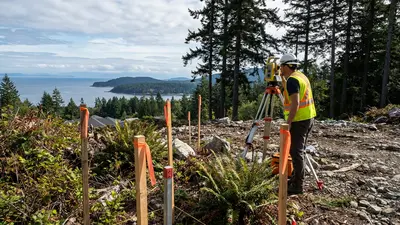
Slope Stability and Development Permit Areas
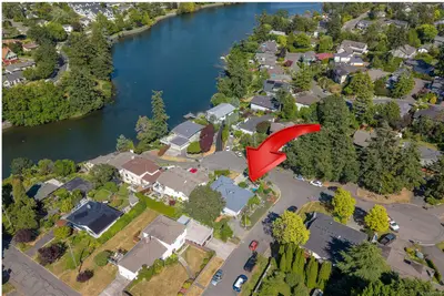
Many desirable properties on Vancouver Island are on slopes — hillside lots in Langford, Bear Mountain, the Highlands, and the Malahat offer views but present geotechnical challenges. Municipalities designate steep slopes as Development Permit Areas, requiring professional geotechnical assessment before development can proceed.
A slope stability assessment evaluates whether the slope is safe for the proposed development. It identifies what mitigation measures are needed — drainage, retaining walls, slope reinforcement — and whether the development could affect adjacent properties. This is particularly important for Bill 44 SSMUH densification projects where adding buildings to a sloped lot increases both load on the slope and the consequences of failure. Our development potential assessment guide can help you evaluate site constraints before engaging a geotechnical engineer.
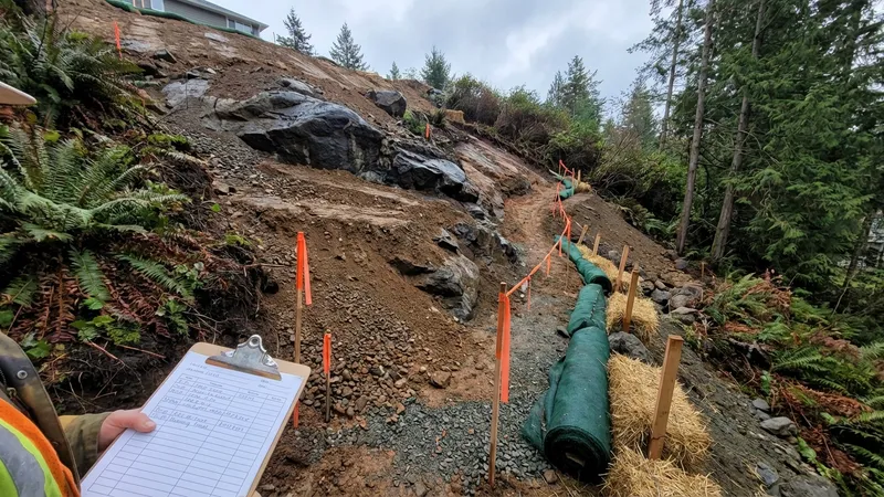
Slope stability assessment on a Vancouver Island hillside lot, where exposed rock and varied soil conditions require careful geotechnical analysis.
Septic and Percolation Testing
Large portions of Vancouver Island remain outside municipal sewer service — much of Sooke, Highlands, Metchosin, the Cowichan Valley, and rural areas of the Saanich Peninsula. Properties in these areas rely on septic systems for wastewater treatment.
A percolation test (perc test) measures how quickly water drains through the soil. The results determine what type and size of septic system can be installed. Some soils drain too quickly (sandy soils that don't adequately filter effluent) or too slowly (clay soils where the system backs up). The geotechnical engineer or a registered onsite wastewater practitioner conducts these tests and designs a system that meets BC's Sewerage System Regulation.
Contaminated Sites
When land is rezoned from commercial or industrial use to residential, contaminated sites assessment is triggered under BC's Contaminated Sites Regulation (CSR). A Stage 1 Preliminary Site Investigation (PSI) reviews the property's history to identify potential contamination sources. If contamination is suspected, a Stage 2 Detailed Site Investigation (DSI) involves physical sampling and laboratory analysis.
On Vancouver Island, contamination is commonly associated with former gas stations, auto repair shops, dry cleaners, and light industrial uses. Properties near Victoria's harbour areas, older commercial districts, and former military sites may also require assessment.
Types of Geotechnical Investigations
Geotechnical investigations range from simple to comprehensive, depending on the project and site conditions:
- Desktop study: Reviews existing geological maps, aerial photos, well records, and previous geotechnical reports for the area. Suitable for preliminary feasibility assessment but not sufficient for building permit applications
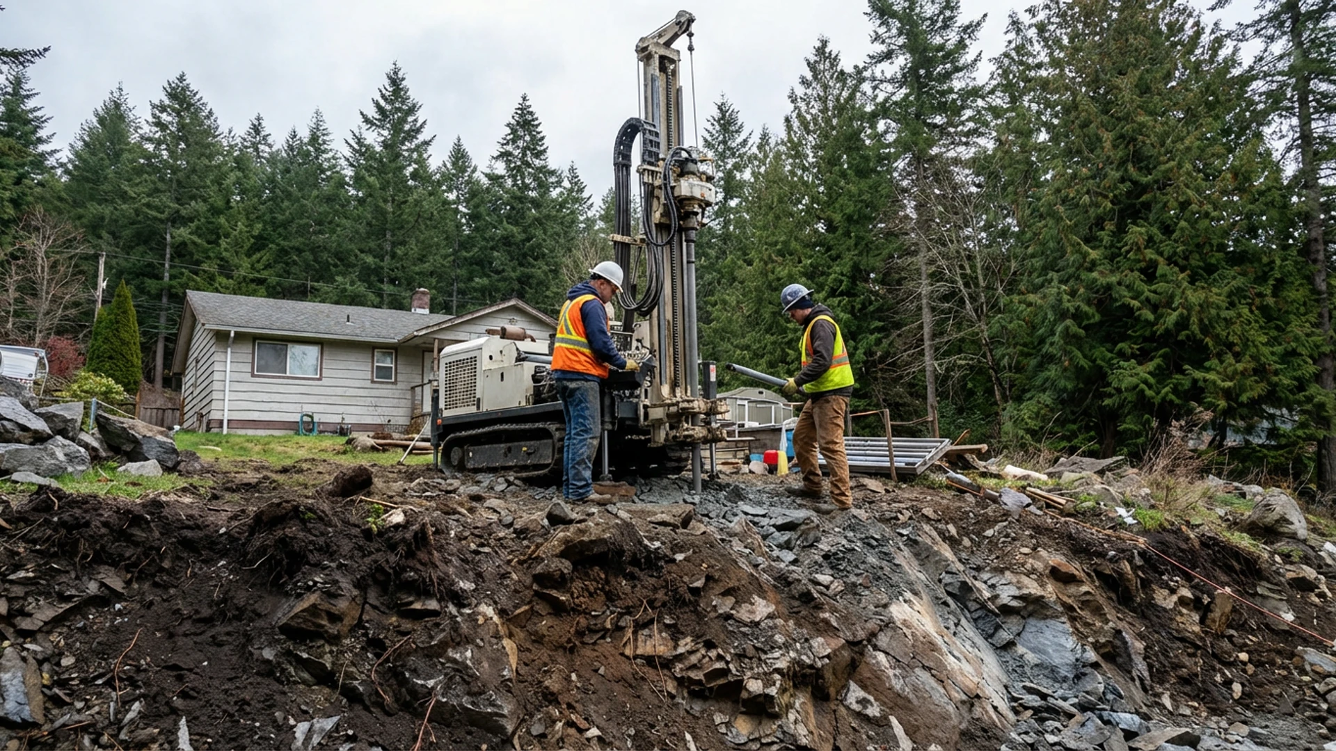
- Test pits: An excavator digs pits (typically 2–4 metres deep) to expose soil layers for visual inspection and sampling. Cost-effective for shallow investigations on relatively flat sites
- Borehole drilling: A drill rig advances a hollow-stem auger or rotary drill to depths of 10–30+ metres, recovering soil samples at regular intervals. Required for deeper foundation design, pile analysis, and seismic site classification
- Cone Penetration Testing (CPT): An instrumented cone is pushed into the ground at a constant rate, measuring soil resistance continuously. Provides detailed, continuous soil profiling and is particularly effective for identifying soil layers and liquefaction potential
Typical Costs on Vancouver Island
| Investigation Type | Typical Cost Range |
|---|---|
| Desktop study | $1,500–$3,000 |
| Test pits (2–4 pits) | $3,000–$6,000 |
| Full geotechnical with boreholes | $5,000–$10,000+ |
| Slope stability assessment | $8,000–$15,000+ |
Costs depend on site access, number of test locations, depth of investigation, and laboratory testing requirements. Drilling costs increase significantly for sites with difficult access or deep investigations.
How to Choose a Geotechnical Engineer
- Verify EGBC registration: Confirm the firm employs registered Professional Engineers (P.Eng.) and/or Professional Geoscientists (P.Geo.) through the EGBC registrant directory
- Vancouver Island experience: Local geology knowledge is essential. A firm experienced with Victoria's bedrock, Langford's glacial till, or coastal marine clay will produce more accurate and cost-effective recommendations
- Seismic expertise: Ensure the firm has specific experience with seismic site classification and foundation design for BC's seismic zone
- Turnaround time: Field work typically takes 1–2 days, but the report can take 3–6 weeks depending on laboratory testing and firm workload
Check Your Property's Development Potential
Before engaging a geotechnical engineer, understand what your property can support. Our free Development Potential Assessment identifies slope, soil, and regulatory factors that affect your Vancouver Island property.
Start Your AssessmentThe Complete Consultant Guide Series
- Overview: Building Your Development Team
- Part 1: BC Land Surveyor (BCLS)
- Part 2: Certified Arborist
- Part 3: Geotechnical Engineer — You Are Here
- Part 4: Building Architect (AIBC)
- Part 5: Structural Engineer
- Part 6: Civil Engineer
- Part 7: Building Envelope Consultant + Energy Advisor
- Part 8: Landscape Architect (BCSLA)
- Part 9: Environmental Consultant (QEP)
- Part 10: Traffic Engineer
Disclaimer: This article provides general information about geotechnical engineering in BC as of February 2026. Site conditions vary significantly. Always engage a registered geotechnical engineer for site-specific assessment. Requirements vary by municipality and project type. This is not legal or professional advice.